
Mapping the Unseen: How Digital Terrain Models Elevate Event Planning
- Aug 11, 2025
- 3 min read
You can’t design for what you can’t see. And too often, site planning for major events starts with flat CAD drawings that barely scratch the surface of what’s actually there.
But when you’re placing temporary infrastructure on sloping ground, managing crowd flow across uneven terrain, or trying to avoid surprises during build, you need more than just a floor plan.
That’s where Digital Terrain Models (DTMs) come in.
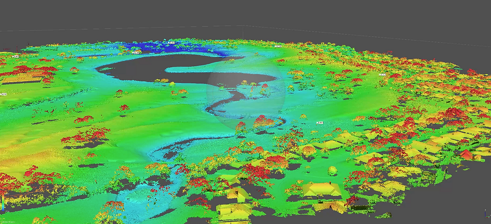
What is a Digital Terrain Model?
A DTM is a 3D representation of the bare earth surface: stripped of trees, buildings, and temporary overlays. It captures elevation changes, gradients, and contours across a site, giving planners a true sense of the land’s topography.
Unlike a Digital Twin, which represents all operational layers of a venue in real time (infrastructure, crowd movement, lighting states, etc.), a DTM focuses purely on the foundational landscape.
Think of it as the bones beneath the skin.
How DTMs Are Created
DTMs are typically generated using remote sensing techniques like LiDAR (Light Detection and Ranging), photogrammetry, or aerial drone surveys. These tools capture detailed elevation data, which is then processed to remove surface clutter such as trees, buildings, and vehicles.
This level of precision allows event teams to work with centimetre accurate models; essential when planning large structures, crowd routes, or accessibility features on uneven ground.
Why It Matters for Events
For stadium builds, city centre takeovers, or rolling countryside festivals, DTMs offer an invaluable baseline for:
Infrastructure placement: Understand how slope affects scaffolding, cabling, or temporary roads.
Crowd safety modelling: Simulate how people move across inclined surfaces and pinch points.
Drainage planning: Anticipate water pooling or run off risks based on terrain data.
Accessibility design: Identify areas where gradient may exceed accessible thresholds.
And importantly, DTMs help reduce late stage surprises. If your site plan assumes flat ground and the reality is a 7 degree slope, your build team’s going to have a bad day.
Real World Insight: Avoidable Stage Tilt
Festival producers routinely flag slope and ground variations as critical planning inputs, especially before pinning down stage, booth, or infrastructure locations. GIS and DTM tools allow teams to measure slope to within centimetres, conduct flow/runoff audits, and plot accurate cut/fill planning, all before anything physically touches the ground
Here’s the risk if they don’t: when slope is discovered too late, everything gets more expensive. Structures might need to be elevated or re-levelled using extra scaff, platforms, or groundworks. Cable runs are rerouted. Sign offs that were already locked in need re-approval from safety consultants. You’ll need more labour to make those changes, usually with less time and more stress.
It’s not just lost hours, it’s lost margin.
DTMs + Digital Twins = Planning Power
On their own, DTMs give you static topography. But combined with Digital Twins, you get a layered, dynamic environment for smarter decision making.
Imagine this:
Start with a DTM to understand the land
Add 3D infrastructure models
Overlay live data from GIS, crowd sensors, or CAD updates
Now you’ve got a planning model that reflects both the real terrain and the operational complexity above it.
Who Needs to Know?
If you’re an event producer, site manager, or technical director, understanding DTMs can save days in rework and thousands in costs. If you’re a creative lead, it means fewer compromises when your grand vision hits real world constraints.
DTMs may not be the flashiest tool in your kit. But they quietly hold the key to more accurate, more efficient, and ultimately more successful events.
Want to explore how DTMs could level up your next site plan? Let’s talk.


Comments